Polihale Beach Sunset Aerial 1

Polihale Beach Sunset Aerial 1

Posted on

Last summer, I flew my drone above Polihale Beach on Kauai but did not create the image that I was hoping for. When I returned in December to try again, I was pleased to experience the ideal conditions which lead to this photograph. Late in the afternoon, the wind was non-existent and the clouds boiled over the rugged cliffs of the Na Pali Coast. I prepared my hexacopter for its initial flight and was ready for takeoff when the sunlight began to penetrate beneath the clouds on the horizon. Though I flew as far as 300m offshore and as high as 100m in the air, this photo was created at about half that distance and elevation during my reconnaissance of the scene.

Be social and share.

Popular Photography February 2015 Nature By Drone Article

Popular Photography February 2015 Nature By Drone Article

Posted on

My most recent article “Nature by Drone” is published in this month’s issue of Popular Photography. In my article, I share what it takes to build and fly larger remote controlled multirotors that can lift cameras that are larger than a simple GoPro. My drone imagery is featured throughout the article, but there are also several images from other professional photographers who are incorporating drones into their work. I finish by discussing some of the legal and ethical considerations that every pilot needs to know before taking off. The double page opening image is an aerial that I created while flying my hexacopter over Puu Pehe on the south shore of Lanai last winter.

Be social and share.

Nooksack River Channels Aerial 2

Nooksack River Channels Aerial 2

Posted on

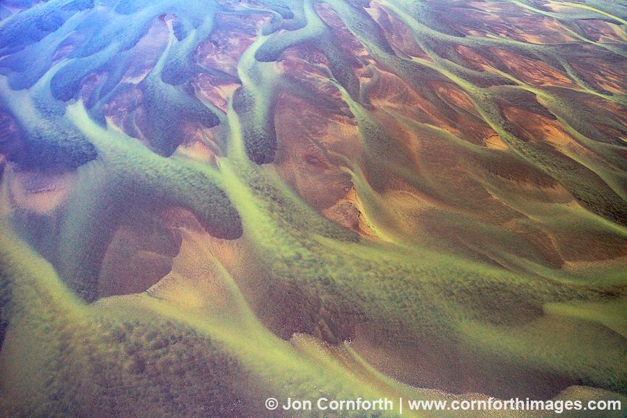
It has taken me almost 6 months to make peace with this image and process it. Of course, a little backstory is required after a statement like that.

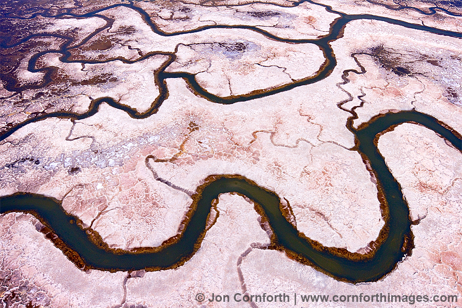
When I started building and flying my own drones last year, I was motivated to photograph interesting aerial abstracts during my travels without having to hire an airplane. I scoured Google Earth for interesting topography and then set out to photograph it. One of the locations where I envisioned flying my hexacopter to produce an image was above the mudflats where the Nooksack River flowed into Bellingham Bay. The satellite views showed an intricate network of braided channels that I thought looked like a painting.

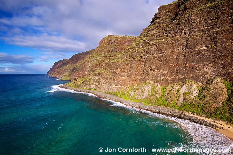
So, back to the difficult part about processing this image. On my second attempt to fly over this landscape, I had secured a permit from the Lummi tribe to walk out on the mudflats. My dad joined me on a gorgeous day in May with ideal flying conditions. I was feeling confident and flew my drone farther and higher than I had ever flown before (roughly 600m out and 100m up) to compose this image. On my second flight of the day, my hexacopter unfortunately experienced a sudden and rapid descent into the terrain below. Ouch. I could see that my hexacopter was sticking out of the water, so after a lot of effort to reach it I recovered it. The submersion damaged most of the electronics and flooded my camera, but at least the memory card was recoverable and the SuperX flight controller is waterproof. Upon reviewing the blackbox data, I discovered that the reason for the crash was a loss of power to one of my motors which upon inspection showed a poor solder connection which I blame on the Chinese manufacturer. I hope that you agree that this is an exciting application of technology used to produce a beautiful image.

Be social and share.

Coleman Glacier Sunset Aerial 3

Coleman Glacier Sunset Aerial 3

Posted on

I hiked up to the Coleman Glacier on Mount Baker several times over the past month hoping to fly my remote controlled hexacopter. Earlier this week, all the conditions that I had hoped for finally aligned. The clouds suddenly and dramatically parted just as the sun set on the western horizon and there was almost no wind. I only had a few minutes to get in the air above the glacier and photograph this dramatic perspective.

Be social and share.

Outdoor Photographer September 2014 Drone Article

Outdoor Photographer September 2014 Drone Article

Posted on

My regular readers are probably aware that over the past year I have been building and flying remote controlled hexacopters in order to create dramatic aerial photos. In this month’s issue of Outdoor Photographer, I share some of my advice from the lessons I have learned from flying a drone capable of lifting a larger camera. The opening images showcase one of my aerial images of Lumahai Beach on Kauai, as well as my previous Canon EOS M camera mounted on my gimbal beneath my Tarot 690S hexacopter. After my crash in early May, I rebuilt using a Tarot 680Pro frame and am now flying a Sony NEX 5 camera body. I hope that readers will enjoy my latest article and find inspiration from what I have have been doing.

Be social and share.

Kee Beach Sunset Aerial 1

Kee Beach Sunset Aerial 1

Posted on

I flew my hexacopter almost every day during my recent trip to Kauai, including at Kee Beach my last two sunsets. I have previously photographed the Na Pali Coast from the shoreline rocks on the far right of this image, but this time I flew my copter from the flat heiau hidden just above. Not only was this a perfect landing zone, but I had it all to myself. I find that it is much too distracting and dangerous to fly around people. I lucked out that there was almost no wind and the sun kept poking through the clouds to illuminate the scene. Dappled light underneath dark clouds is my favorite landscape photography situation. I digitally removed the tiny dots of people on the beach and snorkeling in the water, but also kept the original for my editorial clients.

Be social and share.

Makena Beach Aerial 1

Makena Beach Aerial 1

Posted on

Last year, I resolved to learn to build and fly remote controlled multirotor copters in order to create dramatic landscape images from a unique angle. It took me a little while longer than I had expected, but I am very happy with the types of photos that I am now creating. This aerial view of Makena Beach on Maui is a beautiful example of what is possible by merging this astonishing technology with my creative vision. Sure, I’ve seen aerial images of Makena over the years that were photographed from a small plane, but what is exciting to me is that I did both the flying and the photography myself. My hexacopter was hovering about 300m out and 100m up from where I took off when the setting sun briefly shined underneath the clouds to illuminate the entire scene. This is also my edited version of this photo, because I digitally removed the tiny dots of naked people on Little Beach.

Be social and share.

La Perouse Bay Shoreline Aerial 3

La Perouse Bay Shoreline Aerial 3

Posted on

I’ve been back home for a few weeks now and barely flown my hexacopter. The one day that I did fly, I was amazed at how much the cooler weather shortened my battery life, and thus flight times. When I flew over La Perouse Bay on Maui a few weeks ago, I was conservatively reaching 10 minutes each flight. This beautiful lava shoreline and reef image was created by flying over 400m out and 50m up from the parking lot at the end of the road. It takes my hexacopter less than a minute to reach this distance and altitude. I then hover it in place and move it around to experiment with different compositions. I was especially drawn to the X shape of the shoreline surrounded by the turquoise water.

Be social and share.

Puu Pehe Aerial 2

Puu Pehe Aerial 2

Posted on

Now that I have been successfully flying my hexacopters during my recent travels, I am trying to move beyond the novelty of flying and back to focusing on creating beautiful images. I am especially excited about returning to my favorite landscape subjects and exploring them from this new perspective. This aerial image of Puu Pehe, or Sweetheart Rock, on the south shore of Lanai is a perfect example of the possibilities that I am achieving. I launched my copter from the top of the cliffs on the left, then flew it approximately 200m out and 25m above the ocean to compose this dramatic scene. When I say compose, I do mean compose. While flying my copter, I am viewing the Live View from my camera via a wireless transmitter on my 5″ LCD screen. Once I decide to hover my copter in a particular location, I then remotely trigger the camera to take a picture. Of course, I am still looking for all of the normal compositional elements that I would if I were using a tripod to take a picture, including wave action, dramatic light, and dynamic clouds.

Be social and share.

Ravenswood Slough Marshes Aerial 1

Ravenswood Slough Marshes Aerial 1

Posted on

I just returned from spending a fantastic week in the Bay Area of California. During my visit, I gave 4 presentations about my photography to excited audiences every night from Berkeley to Monterrey. I also finally had the opportunity to meet in person and spend time with many talented and amazing photography friends who I have only known online.

I also brought my remote controlled hexacopters with me in order to do some flying. The above abstract aerial image is from my second attempt at flying over the marshes located in the south Bay near Facebook’s headquarters. I spent one morning last week flying with my friend and acclaimed photographer QT Luong, but realized that I needed to return at low tide. So, on Sunday afternoon I returned with my old college roommate and new friend and gifted photographer Patrick Smith. It was a bit breezy during my second visit, but I got my copter up in the air right at low tide in order to frame up this beautiful composition. I am not yet sure where I am going with this new style of photography, but I am passionate about merging technology and art. To me, it is not just about the cool, gee-whiz factor of building and flying “drones”, but rather using them like any other creative tool to produce extraordinary images.

Be social and share.