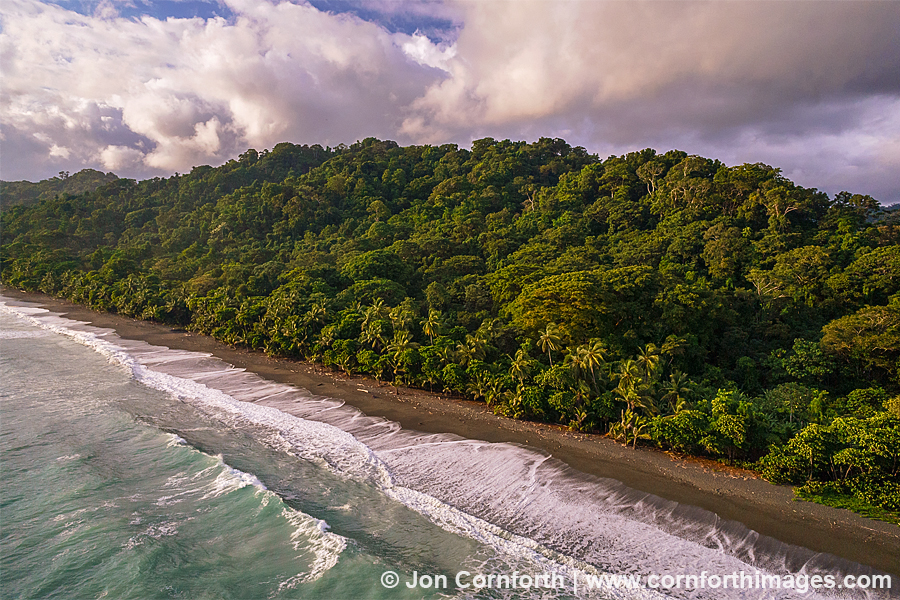
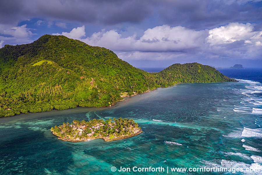
Taumako Aerial 5

Taumako Aerial 5

Posted on

The island of Taumako is another one of the incredibly remote islands that I was fortunate to visit during my 2019 Secrets of Melanesia expedition. Located in the remote eastern part of the Solomon Islands, it is the largest of the Duff Islands and home to a population of less than 500 Polynesian people. In order to come ashore, we had to navigate through a treacherous reef with large breaking waves. Once on shore, the local people welcomed us with their traditional singing and dancing. Some of the unique features of their society include ancient Polynesian seafaring techniques and building the artificial island of Tahua. This islet is situated opposite of the main village and home to roughly 100 people. Towards the end of our visit, I knew that I had to fly my drone in order to create an aerial image of this amazing landscape. I was only able to do one short flight, but the clouds parted right as I took off. This allowed the late afternoon golden light to perfectly spotlight the island.

Be social and share.

Ngerukewid Aerial 1

Ngerukewid Aerial 1

Posted on

In December 2019, I went on an adventure to another one of the destinations that I had a life-long desire to visit. The Republic of Palau is an isolated island nation located in the South Pacific north of New Guinea and to the east of the Philippines. During World War II, the United States captured Palau from Japan after the costly Battle of Peleliu in 1944. Today, it is renowned for its stunning scenery, epic scuba diving, and lakes filled with stingless jellyfish. I was fortunate to be able to spend several weeks photographing all of these amazing subjects. At the top of my list was an aerial photo of the famous Ngerukewid which is a series of uninhabited limestone islands surrounded by coral reefs and sandy shallows. This is one of my favorite images from my trip. I love how the tiny tropical islands look like a jumble of puzzle pieces poking above the the surface of the brilliant turquoise and blue ocean.

Be social and share.

Marovo Lagoon Aerial 2

Marovo Lagoon Aerial 2

Posted on

Prior to my trip the Solomon Islands, I had researched satellite views of Marovo Lagoon and knew that I had to find a way to photograph the Mindeminde Islands with my drone. This beautiful location featured mangrove covered islands surrounded by interconnected reefs and shallow water. My first logistical challenge was that I needed a boat in order to visit the islands. They were located over an hour away from the dive lodge where I was based, but closer to the airstrip where I had landed. Eventually, some new guests were arriving by plane, so I took advantage of the opportunity to use the boat before they landed. My ideal photography conditions for an aerial image like this are when the sun is directly overhead and there aren’t any clouds casting dark shadows on the vibrant landscape. When I was finally ready to fly, there was one massive cloud causing me some trouble. Fortunately, after a few flights where I explored for compositions, the cloud dissipated and I was rewarded with this brilliant image.

Be social and share.

Leilani Lava Aerial 3

Leilani Lava Aerial 3

Posted on

While helping my friends in Leilani Estates on the Big Island, I experienced physical and emotional stress. Still, my own discomfort was insignificant compared to what the residents of Puna have to deal with as this tragedy unfolds. As the land is rendered uninhabitable, homes are being destroyed and lives are being upended. Only Pele knows what she wants to accomplish. Until seen from above, the scale of the destruction is impossible to fully comprehend. So, on my third and final afternoon, I hired a small plane to fly over the eruption. As we approached, I asked my pilot to concentrate on the most active lava fissures. I believe the USGS is currently naming these fissures 8 and 24. As we coordinated lining up this image, I had to pop open my window, ask my pilot to dip the aircraft’s wing, point my telephoto lens, and hope that what I photographed was in focus. Oh, and we both agreed that we would refrain from ever getting caught in the thermal updraft again.

Be social and share.

Ball's Pyramid Aerial 6

Ball’s Pyramid Aerial 6

Posted on

During my recent trip to Lord Howe Island, I flew my quadcopter from a dive boat in order to photograph Ball’s Pyramid. It is an erosional remnant of a shield volcano that formed about 6.4 million years ago and the tallest sea stack in the world at 1,844ft (562m). It lies 12 miles (20km) southeast of Lord Howe Island, thus requiring a boat or airplane in order to visit it. While planning my adventure, I had contacted Pro Dive Lord Howe Island and arranged to join their scuba diving trip whenever the weather allowed. Unfortunately, the day that we set out was terribly cloudy and overcast. I did not even bring my dive gear, since I preferred to photograph from the air rather than underwater. I was resigned to not creating a photo and living with the mental image of at least seeing this immense and forbidding monolith. However, Aaron from Pro Dive wanted me to get my shot and went way out of his way to generously offer to take me back on a private trip the next afternoon. Let’s do it! After our 2pm departure and long boat ride in heavy seas, I did not have a lot of time left to fly. Still, I was able to fly one long and one short flight before we had to turn around and hightail it back to Lord Howe before dark. This is my favorite image with the clear blue sky above and beautiful late afternoon light illuminating Ball’s Pyramid. Wow, just wow.

Be social and share.

Lord Howe Island Aerial 4

Lord Howe Island Aerial 4

Posted on

I recently traveled to Australia for the first time in order to visit remote Lord Howe Island. I had a wonderful adventure, though, it was starting to be their winter, so the weather was not as tropical as I would have preferred. I first saw some pictures of Lord Howe Island over a decade ago and have dreamed of photographing it for my South Pacific project ever since. I had originally booked a trip for last September, but had to reschedule after I broke my left small toe a few days before my departure. Fortunately, it was well worth the wait! The island is barely 6 miles long and features the southermost barrier coral reef in the world. It is listed as a UNESCO World Heritage site and only allows a maximum of 400 visitors at a time. To explore it, I rented a bicycle and did a lot of hiking in the hills on the north end. One morning, I even flew my quadcopter from the top of these cliffs in order to create this beautiful aerial image. I love the direct overhead light illuminating the turquoise water of the lagoon with the clouds above Mount Lidgbird and Mount Gower in the distance.

Be social and share.

Christmas Island Aerial 1

Christmas Island Aerial 1

Posted on

I just got back from another epic South Pacific photo adventure. I created this image while visiting Christmas Island, which is spelled Kiritimati in the local Gilbertese language. It is a remote Micronesian island that is part of the Republic of Kiribati. I first learned about Christmas Island on my way back from American Samoa in 2010. It is very highly regarded among salt water fly fisherman due to its shallow lagoons and scrappy bonefish. The purpose of my trip was to fly my DJI Phantom 4 Pro Obsidian quadcopter over its surreal landscape in order to photograph abstract patterns. WOW! The photos that I had envisioned with Google Maps paled in comparison to those that I was able to achieve with my drone. I especially love the strange submerged sand islands and bold colors of the water in this scene.

Be social and share.

Bora Bora Aerial 1

Bora Bora Aerial 1

Posted on

I photographed this scene while visiting exotic Bora Bora in French Polynesia‘s Society Islands this past December. I have never experienced water that was as turquoise as this. I created this image by flying my new DJI Phantom 4 Pro Obsidian drone over the atoll’s outer reef and waiting for the perfect balance of direct sunlight and clouds. The reason that I was visiting Bora Bora was that I had chartered a sailboat with some friends and my father. I grew up sailing with my family on the Great Lakes, so it was special that my dad was able to join me. I especially like the dappled sunlight below the ocean’s surface and the gentle waves washing over the top of the reef. Ahh, paradise.

Be social and share.

Mataiva Lagoon Aerial 1

Mataiva Lagoon Aerial 1

Posted on

In December, I photographed French Polynesia for the first time. All I can say is, “WOW!” I have always dreamed of visiting remote islands in the South Pacific and have recently focused my photography ambitions on this area of the world. I began my adventure by flying to Tahiti and then up to the remote atoll of Mataiva in the Tuamotus. My main ambition was to fly my new DJI Phantom 4 Pro Obsidian over the incredible lagoon landscape that I had envisioned using Google Maps. Mataiva’s interior lagoon is composed of decaying coral morphed into linear rocky structures. Some of these coral structures peak above the surface, forming about 70 basins. The varying depths of these basins and the clear water gives the lagoon a blue and green tesselated appearance when viewed from above. I thought that it looked like a landscape photographer’s abstract fantasy. The challenges that I had to overcome to create this image were the strong winds and waiting for clear blue sky, because even the smallest clouds left dark shadows traversing across the scene. Mauruuru and enjoy.

Be social and share.

Carate Sunset Aerial 1

Carate Sunset Aerial 1

Posted on

This past November, I traveled to Costa Rica for the first time. My main ambition was to explore a few different locations in order to photograph wildlife, but I also brought along one of my drones to shoot aerials. One of my first stops was the wild and remote Osa Peninsula which is home to Corcovado National Park. Often labeled one of the world’s most biodiverse regions, its wildlife includes scarlet macaws, tapirs, jaguars and squirrel monkeys. I saw a lot of amazing wildlife, but I only nibbled at the edge of the park. I rented a place close to Puerto Jimenz, but drove all the way to the end of the dirt road to Carate Beach one afternoon. This quiet and isolated setting had the Pacific Ocean on one side and impenetrable jungle on the other.

Be social and share.