Cedar MesaPhotos, Pictures, Prints
View Cedar Mesa photos, license Cedar Mesa stock pictures, and buy stunning Cedar Mesa prints by award winning professional photographer Jon Cornforth. To license an image for editorial or commercial use, click on the License Image button and fill out the form. To purchase a fine art print, select your image size and presentation style before clicking on the Buy Print button.
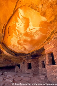
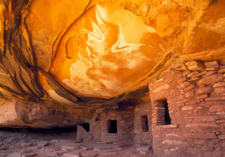
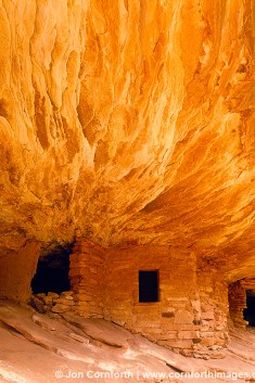
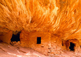
Firehouse and Fallen Roof
Cedar Mesa is a plateau located in San Juan County in the southeastern portion of the Utah. It lies between Elk Ridge in the north, Comb Wash to the east, the gorge of the San Juan River to the south, and Grand Gulch to the west.
While the center of the mesa reaches an elevation of 6,500 feet, the surrounding terrain lies typically at 4,200 feet. This difference in elevation caused the formation of canyons, cliffs, and other erosional features.
While the region’s geology is spectacular, visitors travel here mainly for the area’s pictographs. Throughout this region, archeologists have found scattered ancient Puebloan cliff dwellings. These residences paint a picture of ancient life in this arid part of the world.
The Anasazi inhabitants of Cedar Mesa normally hunted on the mesa tops, where game was more plentiful. Using ladders or breaks in the sandstone, they would descend to into lower areas to eat, sleep, store food and seek shelter. The Anasazi culture flourished in this region from approximately 700-1300AD.
“Firehouse” and “Fallen Roof” ruins are some of photographer’s favorites. These are best photographed during the winter months. Then, in the morning, sunlight flows over the canyon rim. This light reflects off of the rock in front of the ruins, and bathes the the alcoves in a spectacular glow.
Explore with Cornforth Images.